NEWSLETTER
Issue 37 September 2009
WEST MIDLANDS BRANCH
DIARY DATES
NEXT BRANCH MEETING
8
th
September 2009 at Ledbury. Includes site visit to
Aylton Court. See meeting Agenda for further details.
BRANCH MEETINGS 2009-10
Branch meetings take place in November 2009 and
March 2010. Actual dates will be confirmed later.
Our second speaker will be Nick Hymer of
Staffordshire Stone who will be outlining his
aspirations for a more effective exploitation of the
natural stone which is known to underlie certain
development sites. Rather than see this
scraped/pecked/blasted away and carted to landfill,
he is exploring the commercial possibilities of short
term working of such sites to provide supplies of
locally usable stone for repair/restoration projects. At
face value this appears to be a highly sustainable
approach and it will be interesting to follow progress
on this one.
I’ve often said how conscious I am of the
variety of our work and recently I was fortunate to go
on a tour organised by the Southern Staffordshire
Partnership to Fort Dunlop. It was a most impressive
visit. The scale of the building is hard to appreciate
from the M6 at 70mph, but up close and personal its
bulk and mass is hugely dominant. Several aspects
came through in the two very informative
presentations that we were given by Urban Splash.
The sheer size of the project is mind-
boggling. Each floor covers an acre and there are 6
of them. One of the keys to exploiting its enormous
potential was to drag light down into the core from a
central lightwell and this also provided the central
circulation space. The industrial detailing which gives
the building its basic interest and character has been
retained and expressed throughout. And because
ownership is retained by the developers they
maintain control, strict control, over what tenants can
and cannot do. So lighting has to conform to a
certain format, blinds have to be of a particular kind,
window displays are prohibited, signage is to a set
pattern. In effect, these combine to wrap the whole in
a variant on Article 4 directions but one which
doesn’t need to be enforced. In a word, if you have a
unit here this is what you must do. And its effective –
very effective. Enforcement Officers eat your
collective hearts out.
The views from the rooftop are remarkably
expansive and this area is well used as a social
facility. After watching one of the nesting pair of
peregrine falcons take out a pigeon for its lunch and
consume it on the sedum roof you may think twice
about your chicken sandwich, but it makes for a real
conversation piece. There are seats and a large
permanent BBQ available for hire and it’s a very
popular venue with tenants.
CHAIRMAN'S COLUMN
Dave Burton-Pye
NEW WORDS, NEW WORKS
So now we have it. The long awaited successor to
PPG 15, which in itself succeeded the old circular
8/87. I’m keen that whatever goes back from the
West Midlands to HQ as a response encompasses
as many views as possible from the membership so
I’m hoping that we have a good turn-out at Ledbury
and there’s ample time within the morning’s business
session for us to have an informed debate. And if
that’s not enough to whet your appetite then the
prospect of seeing a very fine market town should
clinch it for you.
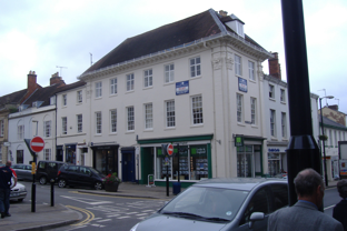
There have been some interesting
developments in Ledbury in recent years, lying
cheek-by-jowl with the historic market place and the
roads leading to it. It is a very pretty town and the
archetypal view along Church Lane to the tower of St
Michael’s church, the latter forming what Gordon
Cullen so aptly termed a “full stop”, must be one of
the most photographed, drawn and painted scenes
in the region. So make sure your memory card has
spare capacity.
In addition we have two fascinating
presentations lined up. Jez Bretherton is the
Heritage Advisor to Natural England here in the West
Midlands and is coming along to talk about their
Higher Level Stewardship grants for
repair/restoration of historic farm buildings. For those
who remember the meeting that I hosted here at
Codsall a couple of years ago, the enormous
complex at Chillington Hall has benefitted from this
particular grant regime (and very good the pigsties,
implement store and acorn roasting house look too).
It will be good to hear first hand about the philosophy
and practicalities of these grants.
Newsletter 37
page
1

The second element of the presentation was
a potted history of Urban Splash and although I’ve
seen variations on this on several occasions, this
one somehow seemed better than others and I came
away with a very positive view of the whole scheme.
I did venture to suggest that whilst such undertakings
had proved their worth in towns and cities it would be
good to see a similarly ground-breaking approach to
countryside regeneration – but my suggestion for a
splinter group called “Rural Plop” didn’t obviously
find favour………. Nonetheless I do think it would
make an extremely good venue for one of our urban
meetings and I’m making enquiries along these lines.
I shall look forward to seeing as many of you
as possible at Ledbury.
But these particular premises, given extreme
ingenuity, will survive to give future generations a
very real taste of what could once be found in every
Black Country street.
The Editor
EDITORIAL
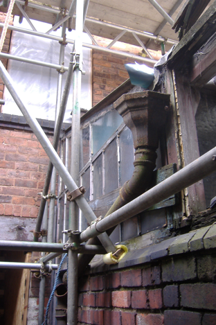
INDUSTRIAL ARCHAEOLOGY
On 8th July, wearing my
West Midlands Historic
Buildings Trust
hat, I was able to take part in a group
visit to the J W Evans works in Birmingham’s
Jewellery Quarter. This is now English Heritage
property and phase I envelope consolidation work is
on site. The project philosophy is to reinstate ‘as is’ –
that is, to the precise appearance of the works on the
day it closed for business in 2008. After
consolidation, English Heritage have to work out how
to afford public access to this small-scale and tightly-
packed warren of workshops and stores, complete
with every tool, appliance and a large quantity of
stock-in-trade. Even the dirt of 2008 is to be retained.
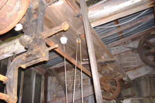
J W Evans – shafting detail
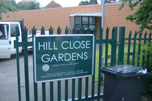
BRANCH MEETING
Day Theme :
HISTORIC GARDENS IN A
HISTORIC TOWN SETTING
22
nd
June 2009
The 22
nd
June Branch Meeting and activity took
place at Warwick, organized and hosted by Roger
Cullimore of Warwick District Council, to whom our
grateful and appreciative thanks. The meeting took
place at the Hill Close Gardens Visitor Centre on the
perimeter of the historic town of Warwick, adjoining
the Racecourse. After the meeting we had the
opportunity to explore Hill Close Gardens
themselves, a very rare and unusual survival.
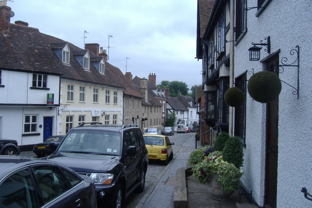
After an hour at liberty for lunch in central
Warwick we went on walkabout, noting the degree of
often covert half-timbered survival and the physical
evidence of the Great Fire of Warwick in 1694. We
went on to explore the periphery of Warwick Castle
itself, that high-footfall tourist magnet on the Stratford
trail, concluding at Mill Gardens with its remarkable
views of the river and Castle.
VIEW OUT OF THE WINDOW
22
nd
June 2009
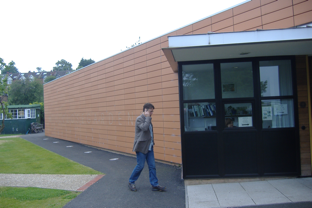
The Branch meeting was held in the Hill Close
Gardens Visitor Centre, a 21
st
Century contemporary
style building aimed at achieving low energy
consumption. The building was commissioned to
provide adequate accommodation for the
administration of the Gardens and to provide an on-
site facility for school visits.
Architects
Design Engine
from the Home
Counties were chosen through an architectural
competition, with their design being superior in
practicality to the other two short-listed entries.
In form the Visitor Centre is a single-storey
flat-roofed box on a triangular plan. The box
interpenetrates with the surrounding space by means
of an open entry passage flanked by a ticket and
enquiry office projecting from the envelope and a
timber pergola at the rear. The East wall is almost
entirely glazed, enabling users of the Education
Room to view the Gardens from where they sit.
The building package includes public toilets
and a kitchen which enables the education room to
be used as a cafeteria. The main public frontage is
J W Evans Works – rear yard detail
J W Evans is not unique in its virtually 100%
degree of survival, but the experience was a salutary
reminder of the immense Industrial Archaeology
resources of the West Midlands. So much has gone.
Newsletter 37
page
2
clad in orange ceramic tiling with horizontal
rustication and engraved lettering. Other frontages
are a mixture of slightly textured render and timber
cladding. There is a sedum roof. A small roof-
mounted wind generator makes a gesture in the
direction of self-sufficiency but only makes a modest
contribution to meeting the building’s energy
consumption. There is a retractable external awning
for the education room’s glazed wall, to prevent
excess solar gain.
Generally, the Visitor Centre proved a good
meeting environment, although the double glazing
was not proof against the noise of garden machinery!
The visible beams in the ceiling of the education
room looked rather odd, as though they were a kind
of chipboard glulam.
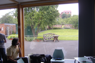
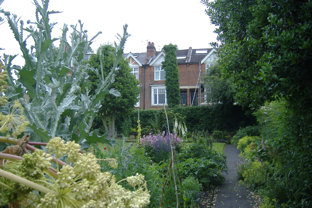
As already noted, the view out of the window
was indeed the Hill Close Gardens themselves,
rising up the slope towards central Warwick.
Unfortunately, the modern social housing
immediately to the south of the Gardens was of no
architectural interest whatsoever and detracted from
the interest of the view.
HILL CLOSE GARDENS,
Warwick
22
nd
June 2009
Introduction
The Listing Description (Grade II*) provides a
succinct summary of the qualities and development
history of Hill Close Gardens. So here it is. All text
quoted from the Listing description appears in italics.
Development History
In the late Cl8 and early Cl9, many larger towns had
groups of small rented gardens forming a ring
around the densely developed town centre. These
pleasure garden plots were typically subdivided by
hedges into individual gardens of between an eighth
and a sixth of an acre. The gardens were laid out for
ornament and the comfort of the owner and were
used to grow a mixture of productive and ornamental
plants. The expansion of towns in the C19 destroyed
the majority of the Cl8 rented garden sites, but a
number of gardens of similar size and function were
laid out in the first half of the Cl9
,
including
Westbourne Road Leisure Gardens, Edgbaston,
Birmingham (qv). A national survey (Lambert 1994)
has indicated that very few of these sites survive
either in their original form or, indeed, at all.
In the early C19 Warwick was hemmed-in by
Warwick Castle and Castle Park (qv) to the south,
the Common to the west, the grounds of Warwick
Priory to the north, and St Nicholas’ Meadow to the
east, which restricted the expansion of the town.
This resulted in much in- filling of the town centre
and consequently a need for gardens on the edge of
the town for those able to afford the c £100 (f50 for
the freehold and about the same sum for fittings left
by the previous owner) needed to acquire such an
amenity. The addresses of the occupants of the Hill
Close Gardens in the Cl9
are predominantly in the
part of the town where the degree of in-filling was
greatest.
Before its development as gardens, the site
was a field, Hilly Close, on Linen Hill, bounded on
the north by Linen Lane (now, 2000, Linen Street),
on the east by the gardens of houses in
Cocksparrow (now Bowling Green Street), and on
the west by the Common Brook, with further fields to
the south. In the later C18 it seems to have
belonged to William Wilson. The Close was first
divided into gardens in 1845, by Edward Wilson of
Exhall, making it one of several similar plots of
gardens around the town. By 1851 the site has been
named Hill Close Gardens, and the eastern side had
been laid out with a service lane running south from
Linen Street, off the eastern side of which were nine
plots, and to the west, in two rows a further four
plots, making a total of thirteen plots. The west side
of the Close was still pasture but the fields to the
south had become gardens and the churchyard of St
Paul’s church.
In the I860s the whole Close was put on the
market. An advertisement in the Warwick Advertiser
(14 July 1864) refers to the sale by John Margetts of
‘highly valuable building or garden ]and ...
subdivided and let in 35 lots as garden ground, the
whole 4a 3r 2p’. Through the sale. the land came
into the ownership of Mark Philips of Welcombe,
Stratford-upon- Avon. By this date the division of the
gardens was complete, making a total of thirty-two
plots surrounding the churchyard on three sides This
had involved the construction of two further lanes
running south off Linen Street, parallel and to the
west of the original access lane. Following the sale,
most of the gardens were sold off as individual units
until by only six still belonged to the Welcombe
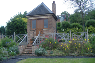
Visitor Centre – main frontage and Reception Office
View over Hill Close Gardens through glazed wall
Glazed wall from outside. Note poor quality
residential development to left.
Newsletter 37
page
3
estate. This division of freehold made development
of the site difficult.
The basic layout of the site remained
unchanged until the early C20 when some housing
development, St Paul’s Close and St Paul’s Terrace,
encroached. This resulted in the loss of eight plots
along the northern edge of the site, the previous
layout of the gardens being reflected in the
development. Additional stabling for the race course
replaced the two plots in the south-east corner of the
site in the mid C20, and caused a slight modification
of the boundary of the adjacent garden to the north.
This reduced the number of plots to the nineteen
which exist today (2000).
In the 1970s the freehold of the gardens,
with the exception of the three eastern plots adjacent
to the Bowling Green Hotel (later the Westgate
Hotel), was gradually acquired by Warwick District
Council for a housing and car-parking scheme; the
gardens became almost entirely uncultivated.
Planning consent for the housing lapsed in 1994
and, as a result of community interest, the District
Council encouraged volunteers to undertake the
clearance of the site, and a restoration plan was
commissioned in 1997-8. One of the plots and a
summerhouse adjacent to the former Westgate
Hotel was restored for a television programme in
1999. Today (2000) the site remains in divided
ownership, the majority belonging to the local
authority.
The survival rate for this type of site is
extremely low, with most examples having
disappeared under built development. Where they
do survive, it is generally as allotment sites with
hedges and buildings removed.
Description
The c1.25ha site comprises nineteen individual plots
containing an average of 500 square metres which
are now (2000) divided by hedges of hawthorn, holly
and privet, brick walls and iron railings. It is likely
that all plots were originally enclosed by hedges,
although individual ownership from the 1860s led to
a greater diversity of boundary treatment. Today the
majority of the site is enclosed by green-painted
metal security fencing c 3m high. The eastern plots
which remain in separate ownership are enclosed to
the north by a property in St Paul’s Terrace, and to
the south by the race course stables. To the east,
these plots are today enclosed by temporary fences
which separate them from the Westgate Hotel which
is the subject of redevelopment. The site occupies a
west- facing slope which falls from the eastern
boundary to the Common Brook which forms the
western boundary. From the higher, eastern plots
there are extensive westerly views across the race
course and properties in Linen Street to agricultural
land west of Warwick.
The Garden Plots
The garden plots are arranged in five blocks of
various lengths which run from north to south.
Service lanes or paths separate the three western
blocks, while a further service lane runs between the
two most easterly blocks. Plots in the second and
third blocks from the east share a common
boundary, and are not separated by a path. Late
C20 clearance of undergrowth on the site has
revealed many of the boundary hedges of hawthorn,
privet and holly which enclosed the gardens,
together with a Cl9 brick wall to the east of plot 25
and C19 spiked iron railings to the north of plot 12.
The gardens retain a collection of mature standard
fruit frees, some of which are of Cl9 origin, while
some new fruit trees have been planted (late C20)
on cleared plots in the positions of trees indicated on
the 1886 OS map. A large mature vine is trained on
metal posts and wires parallel to the southern
boundary of plot 25.
Clearance has revealed the late C 19 path
layout in some gardens (plots 17, 18), while
elsewhere the late C19 path layout is now (2000) in
the process of reinstatement. The southern half of
plot 19, adjacent to the southern boundary of the
site, is today used as a nursery area, with the
remains of a late C19 or early C20 range of brick
and timber glasshouses and frames surviving on the
west side of the plot. A mid C20 metal and timber
shed is today used as a garden office, while further
mid and late C20 sheds stand on plots 23 and 24
which have remained in continuous cultivation to the
present day. Today only the most western group of
gardens, plots 29—31, remain in an overgrown
condition.
Eight brick-built summerhouses of various
designs survive on the site. Of these, that on plot 18
dates from before 1851 (Board of Health map), and
four on plots 7, 17, 19 and 25 from before 1866 (plan
annexed to 1866 deed; three are listed grade II).
Two further late C19 summerhouses are shown on
the 1886 OS map (that on plot 5 listed grade II),
while a further building was constructed c 1900. All
the summerhouses occupy sites at the eastern end
of their plot, so exploiting views across the race
course and Common. The summerhouses were
decorative buildings, equipped variously with
fireplaces, stoves, gas lights, and, in one case, a
‘patent earth commode’. The remains of two other
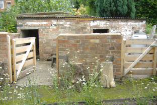
buildings survive comprising a mid C19 brick bothy
and a late C19 or early C20 brick-built pig-sty on plot
16.
Two C19 inventories show that the Hill Close
Gardens had a recreational as well as a productive
role, and this continued into the 1920s, although
during the early C20 the growing of vegetables had
increased in importance. This process was
encouraged by the Dig for Victory campaign during
the Second World War and austerity during the
I940s and early 1950s. Today (2000) the gardens as
revealed through late C20 clearance and
reclamation closely reflect the layout shown on the
1886 OS map with summerhouses of various
designs, fruit trees, complex path systems and
terraces.
Further Information & Walkabout
The gardens have been recreated to a scheme
prepared by landscape architects that more evokes
than exactly reproduces the totality of the layout and
planting before abandonment. As the Listing
Description point out, some the trees and shrubs are
survivals, as of course are the structures and some
of the boundary treatments. Some paved paths also
seemed to be authentic.
The Gardens are managed by a very small
paid staff, including the Site Manager. The greater
part of the maintenance and presentation work is
undertaken by volunteers. Volunteers have a degree
of choice in species planting to suit their own
inclinations.
Public opening takes place on Saturdays,
Sundays and Bank Holidays Spring-Autumn, with
pay access. Groups may visit by appointment at any
time during the week. A range of plants and
souvenirs can be bought on site, as can light
refreshments. Visitors are free to wander around the
complex access path network.
Maintenance and upkeep is to a high
standard. The new landscaping scheme has
included some spectacular plants such as giant
artichoke and giant hemlock as well as more homely
flowers and vegetables. One plot is cultivated
Newsletter 37
page
4
according to WW2 ‘Dig for Victory’ principles.
Decorative use has been made of uprooted dead
tree stumps.
The gardens occupy a west-facing slope,
and the higher plots command a view of the
Racecourse to the west. The IHBC walkabout took
place on a ‘non-public’ day with only staff and
volunteers present on site. It was a remarkably
tranquil experience walking through intricately
compartmented greenery listening to copious
birdsong.
permitted development in the interests of protecting
and enhancing the amenities of the Gardens
themselves.
(Untenanted) pigsties
Hill Close Gardens – shed detail
Gazebo with terrace
Small summerhouse
Exotic planting!
Another member was concerned at the
visual dominance of modern housing to the SE and
south of the Gardens. Their visual contribution was
negative and they were not screened off in any way.
Overall, the reinstatement and operation of
Hill Close Gardens is an enterprise that is largely
community-led and community operated, ticking all
the right HLF boxes and guaranteeing continuing
maintenance.
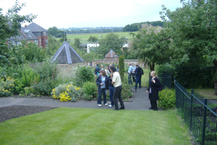
View of Gardens down the slope to the Racecourse
Comments
One member rather regretted that no single plot had
been retained in its ‘wild’ state, as an example of
how deeply overgrown the Gardens were before
reclamation.
Housing overlooks the Gardens to the east and
south. Terrace houses in Bowling Green Street
overlook from above. Some retain their late C19
features and are a positive amenity, but others have
modern glazing and concrete interlocking tiles which
ultimately detracts from views over the Gardens from
the west. There might be scope for designation of a
Hill Close Conservation Area (unless one already
exists) with an Article 4 Direction restraining
WARWICK TOWN CENTRE
22
nd
June 2009
Town
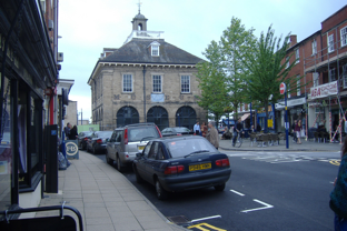
The afternoon walkabout started at the Market Hall
(William Hurlbutt, architect/builder) of 1670.
Originally possessing an open ground floor arcade,
the hall was strikingly reminiscent of that at Abingdon
(Oxon) with hipped roof and central lantern.
Execution was in stone. In the C19 the arches had
been infilled with tracery reminiscent of that
Newsletter 37
page
5
appearing in the late C17 rebuild of St Mary’s
Collegiate Church. The building was currently in
museum use but was closed for refurbishment.
Discussions about partial conversion to a tourist
office had taken place without any firm conclusions.
More giant pilasters (St Mary’s Church to right)
Market Hall, Warwick
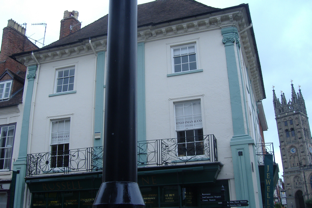
The walkabout swiftly took us into that part
of the town which had been rebuilt following the
Great Fire of 1694. The rebuilding scheme had
involved the specification of ‘anchor’ three-storey
buildings at the street corners. These were imposing
stone structures in English Baroque, with both giant
corner pilasters and sometimes broken pediments.
Most were startlingly reminiscent of Francis Smith’s
Baroque work at nearly Stoneleigh Abbey. English
Baroque buildings are quite rare, so Warwick was
revealed as having unusual architectural interest in
this regard.
Six-bay corner block
Castle
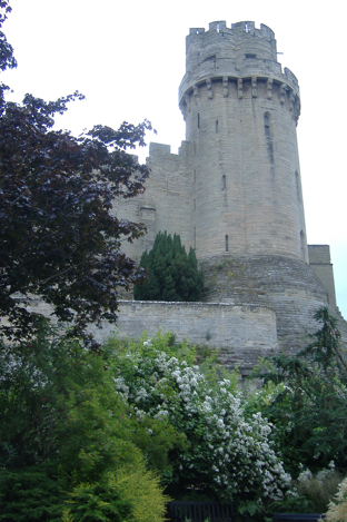
Warwick Castle is on the international tourist trail
focussed on Stratford-on-Avon. It remains in the
ownership of the Madame Tussaud organisation and
is run purely as a visitor attraction with an average
entrance fee of almost £20. However, the Castle has
a lot to offer, from peacocks in the gardens to the
ability to wander through an enormous and still
largely medieval structure, including climbing to the
tower tops.
Warwick Castle is unusual in that its then
owners declared for Parliament in the English Civil
War, thereby safeguarding the building from the
slighting that so severely damaged the majority of
English Castles, even Kenilworth nearby with its
dazzling Henry Yevele apartments. Thereafter,
successive Earls of Warwick had refrained from
major alterations. So the Castle retains its medieval
outline with the massive Guy’s and Caesar’s towers
intact to their highest battlements.
Corner property with broken pediment and giant
pilasters
Warwick Castle – sunken carriage drive
The IHBC walkabout took us through the
Castle perimeter, including the ticket office courtyard
(formerly a stone stable block) and over a timber
bridge that ‘grade-separated’ the children’s
playground created for use by paying visitors from
Newsletter 37
page
6
the general public on the footpath. This took us into
an early C19 carriage drive cut into the stone of the
crag on which the Castle is sited.
Another stone gateway let us out on to the
alignment of the former Town Wall. From there, Mill
Street led down to the River Avon. This street is
largely half-timbered, albeit very heavily made-over,
and was clearly occupied by seriously rich people.
Mill Street is now a cul-de-sac.
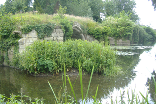
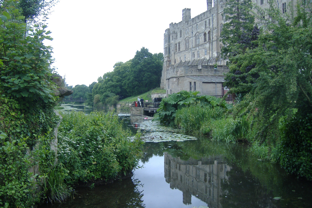
Mill Gardens – ruined medieval bridge over Avon
Mill Street, Warwick
Mill Gardens
Mill Street is a cul-de-sac. But it is possible to walk
further on by paying a £1.50 admission fee for Mill
Gardens at the far end. This is another beautifully
kept garden. But a garden with a wonderful set of
views.
It is immediately below and to one side of
riverside cliff on which the Castle stands. So the view
from the garden is up and along the immensely tall
and long river frontage of the Castle. At the closest
angle of the Castle is the immense Caesar’s tower
on top of a tall battered plinth.
And then there is the River Avon itself. The
garden is only just above water level and adjoins a
weir, so the single most important sound is that of
falling water. There are views over and along the
river.
south wall of the Castle from Mill Gardens
Here is the key to Warwick’s existence. The
Garden adjoins the substantial but decaying
remnants of a medieval bridge. This is the ancient
crossing point on the Avon that the castle was built to
control. This is the reason for the existence of Mill
Street, which was simply the bridge approach on a
diagonal line avoiding a steep slope.
The bridge was suffering break-up of its
upstream cutwaters through long term water action,
and the growth on top was clearly loosening joints
and accelerating decay. Here is a highly significant
structure, with no functional use, that will require
substantial sums of money and a lot of practical
difficulty to repair and consolidate. Being over and in
a river, there is an Environment Agency dimension
as well as the wildlife issue. And, once consolidated,
the structure will need regular maintenance to
safeguard it. So, at very least, any scheme ought to
include a sensitive footbridge conversion to afford
regular, easy access.
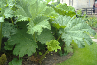
In the Mill Gardens, there was another
wonderful plant, a sort of giant (and indeed gi-
normous) rhubarb right out of the C20 English
Garden plantsman’s vocabulary for waterside
locations. A little notice said that seedlings of this
striking plant were available on sale.
The Mill Gardens were a sensory and scenic
delight. The current admission charge is used to
raise funds for charity.
Caesar’s Tower & plinth from Mill Gardens
Newsletter 37
page
7
Mill Gardens – giant rhubarb detail
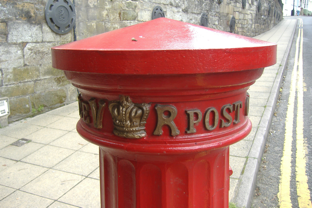
West Gate – detail of Doric VR pillar box
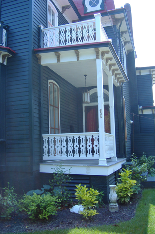
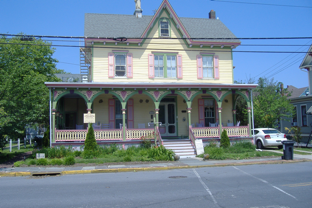
CAPE MAY, USA
The Editor
At the end of my visit to the USA I spent two days in
Cape May, New Jersey. Cape May is something of a
mini-Florida. It is a low-lying peninsula at the
southern extremity of New Jersey state, with the
Atlantic to the east and Delaware Bay to the west.
Geologically, it seems to have been built up by
coastal drift in the same way as Orford Ness in the
UK. Back in the 1860s it was developed as one of the
first seaside resorts in the Eastern US.
Being at the end of a ‘road to nowhere’ Cape
May seems never to have faced major
redevelopment pressures, with the result that a great
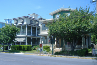
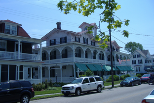
deal of the mid-late Victorian resort still survives,
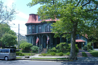
typified by a substantial collection of detached villas
fronting narrow tree-lined streets.
Economically, Cape May town continues to
function as a seaside resort, with a long promenade
fronting a wide, sandy beach. In fact, the original
town was built slightly inland from the beach, so that
the promenade area is of mostly C20 origin.
However, much of the marketing is based on the
historic interest of the Victorian resort itself. There is
a portfolio of trail leaflets, guided walks, hire
quadricycles and horse carriage hire.
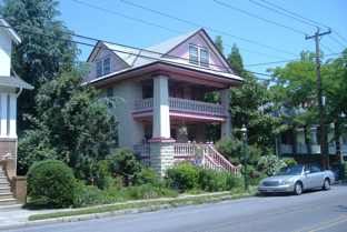
Cape May Town is flanked by a more modest
settlement at Cape May Point. Again developed in
the 1860s, a series of detached villas line wide
streets laid out in the standard US grid pattern. I was
told that winter inhabitants totalled no more than 400,
whilst summer population was as much as 4,000. So
the picture is, clearly, of a settlement of holiday
homes for the well off. A number of original villas
survive in good condition. There is no shop of any
kind but there is a Post Office and a mini town hall,
as well as a (volunteer run) fire station. A lighthouse
and a WW2 fire control tower are managed and
opened to the public as historic monuments. Cape
May Point is astonishingly quiet and peaceful.
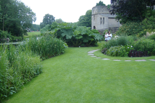
Mill Gardens lawn
WARWICK - Other Notes
22
nd
June 2009
There are significant reminders of the Medieval
Walled Town. The east and west ends of the High
Street and Jury Street feature surviving medieval
gateways, both of which are topped by chapels, the
West Gate chapel having a much imposing tower
than that at the East Gate. The East Gate chapel is
partially occupied by an operational school
classroom and is in increasing need of repair, so we
were told on 22
nd
.
Warwick – West Gate Chapel to left, Lord
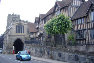
Leycester’s Hospital to right
Warwick has two wonderful ‘Doric Column’
pillar boxes dating from 1856. These are located at
the West Gate and East Gate respectively. Street
furniture at its finest.
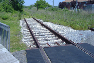
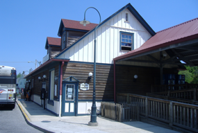
Cape May Town – former railway station
Newsletter 37
page
8
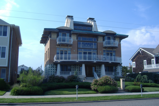
Villa, Cape May Town
Two storey verandahs – shade optimised
Gingerbread work – fretted arches
Ground floor verandah only
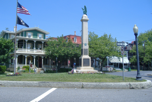
Villa balcony in fretted wood
Shocking pink décor
War Memorial with more villas
Newsletter 37
page
9
Tracks in the redundant Railway station- the station
is now the Bus station.
Art Nouveau villa on Promenade
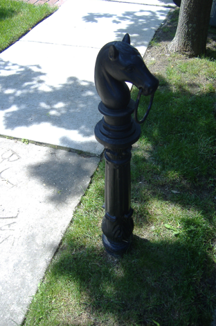
sidewalk hitching post, Cape May Town
EDITOR'S SHOPPING LIST
Your Editor welcomes, for the next Edition of the
Newsletter (No 38), to go out in November 2009, the
following:
Personal news of moves, retirements, arrivals;
Copies of announcements and press releases;
Case Studies;
Letters;
Articles on Law and Techniques;
Book Reviews.
Material for inclusion in No 38 should,
preferably, arrive not later than the end of October
2009. Please contact your
Newsletter Editor
:
Peter Arnold, 16 Elmbank Road, Walsall WS5 4EL;
01922 644219;
pdarnold@care4free.net
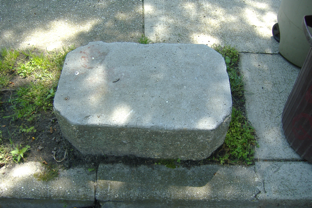
Cape May Town, Carriage mounting block
PICTURE POSTSCRIPT
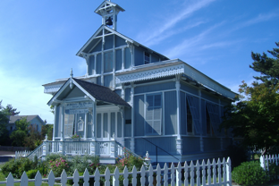
Christchurch (Episcopalian) at Cape May Point.
Shutters instead of windows. Only used for worship
in the summer.
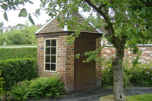
Hill Close Gardens Visitor Centre – from site
entrance
Newsletter 37
page
10